Showing posts with label Natchez Trace Parkway. Show all posts

Tuesday, December 4, 2012

Tombstone Tuesday, Chamberlain, Jefferson County, Mississippi

Copyright 2012, CABS for Reflections From the Fence

This family cemetery located at Mount Locust, on the Natchez Trace, near Cannonsburg, Jefferson County, Mississippi,  is represented on Find A Grave, with very good photos of five gravestones. (Note on Find A Grave it is named the Chamberlin Cemetery, I have used the spelling of Chamberlain, as found on all of the inscribed stones.)

This is the family cemetery of the founder of the Mount Locust Inn, William Ferguson and his widow, Paulina Burch (Ferguson-Chamberlain).  Six of Paulina's sons, four with William and two other sons with her husband James Chamberlain are interred here.  There is also a visitor, Robert Law, who died here at the inn in 1825, buried here.  There are also a number of 'pre-need' stones here, which are not shown on Find a Grave, or here at Reflections, out of respect for privacy of those individuals.


I posted the slave cemetery of Mount Locust.


.

Tuesday, November 20, 2012

Tombstone Tuesday :: Mount Locust, The Slave Cemetery

Copyright 2012, CABS for Reflections From the Fence

At Mount Locust, on the Natchez Trace Parkway, there are two cemeteries, one for the family and one for the slaves.


Signage tells us:

Only one unmarked stone remains. The names of persons known to be buried here are:

Cielious Washington
Marcus Perrymam
John White
Gabriel Tyler
Richmond Tyler
Jackson Tyler
Tommy Turner
William Turner
Abraham Allen
Esther Jackson

I looked hard, with all the leaves, it was a bit difficult finding that one stone, but, at last, middle of the photo to the left, one small white stone, barely visible.


.

Sunday, November 18, 2012

THE Trip, THE Encore' :: Driving Natchez Trace, Day Four, Part Two

Copyright 2012, CABS for Reflections From the Fence

Day four on the Natchez Trace was busy and full of photos, 285 photos!  We are almost to the end of our drive of 434 of the 444 miles of the Trace, the weather was quite pleasant.  It was a great day!

One of our stops was at Mount Locust.  Mount Locust was built in 1780, and is one of the oldest structures in Mississippi.  It was a working plantation and a Inn.  It is the only surviving Inn from the time when the Old Natchez Trace was in it's prime, there had been more than 50 Inns or stations at one time.  It has been restored to show what the home looked like in 1810.


Look at the size of those tree stumps holding the porch up.  I so wanted to sit in that rocker and rest a spell.


The rooms are charming, all these years later:


Children's toys, love, love, LOVE, that hobby horse:


The storeroom:


There were two cemeteries on the property, they will appear in a future blog post.

We made a few other stops before jumping off the Trace and back into the real world, the most memorable was Emerald Indian Mound.  It is actually off the Trace a bit, and the road in was, well, not really meant for Jolly and Tana.  We did not see any warnings before we had started down the twisting, narrow, bumpy road.  Once committed, there was NO turning around, Man was a bit white knuckled, I sat quietly, praying! LOL  But, in the end, there was a nice enough turn around and enough parking for all 53 feet of the train (err, Jolly and Tana), especially since we were the only visitors at that time.  The quiet was all encompassing.  This mound is the second largest "temple mound" in the United States.  It is an 8 acre mound, used between about 1300 and 1600 by the Mississippians, who were ancestors of the Natchez Indians.  It was designated a  National Historic Landmark in 1989 by the Department of the Interior.  The photo does not show the size well, on the far right you can barely see a stairwell handrail.  This mound is 30 foot tall.


We spent the night over in Vidalia Louisiana.  We got to cross the Mississippi River twice in two days, so, I shall end this post with two photos of that bridge, one as dusk with the golden light and one at night.


.

Thursday, November 15, 2012

THE Trip, THE Encore' :: Driving Natchez Trace, Day Four, Part One

Copyright 2012, CABS for Reflections From the Fence

Day four of our drive of the Natchez Trace resulted in 285 photos, and too many wonderful things photographed to share all in one post, so, there will be more than one.  We found four cemeteries (see future posts), an abandoned town, several home sites and several more Native American burial mounds.

The first mound site was called Boyd (no photos published).  The next stop was Reservoir Overlook at mile marker 105.6.  The Ross Barnett Reservoir is formed by an earth filled dam of the Pearl River.  It was a peaceful and pretty place.


About one mile away at mile marker 104.5 is another section of the Old Trace you can visit.  This particular section is level with the surrounding lands.  Many sections of the Trace are like deep gulches (see below).


This is Rocky Springs Methodist Church, built in 1837.  There is a cemetery here full of interesting stones.  Yes, a future blog post or two, I took many photos in that cemetery and did not get all the stones.


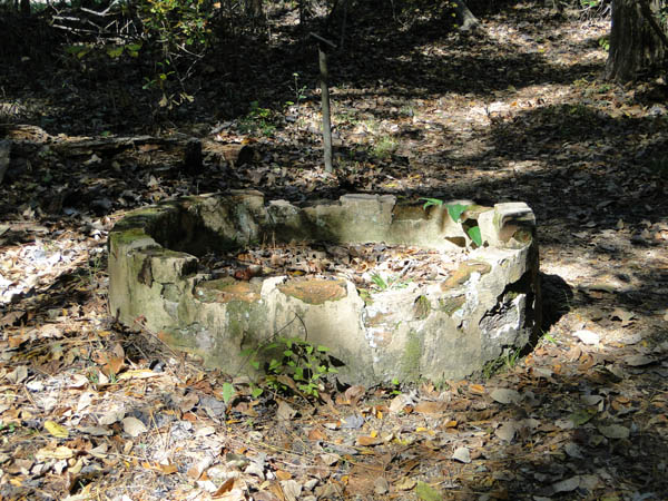
The nearby town (nearby as in just steps away) of Rocky Springs (mile marker 54.8) was a "station" along the Trace, was a thriving community from the 1790's till sometime around the mid 1860's.  The spring that originally drew it's citizens dried up, the Civil War, yellow fever and insect devastation were more than the locals could deal with.  About all that is left are a couple of safes and a couple of old dried up cisterns.


Our last stop of today's post is called Sunken Trace at mile marker 41.5.


Here you can get a good idea of how deep the Trace is beaten down - Man and Cappy taking a lookie see.


Our last two stops on the Trace were Mount Locust and Emerald Mound.  Mount Locust had two cemeteries!  Emerald Mound was amazing, so much so that the photos really don't do it justice, but, I shall try!


.

Tuesday, November 13, 2012

Tombstone Tuesday :: Drane Cemetery, French Camp Academy, Natchez Trace, Mississippi

Copyright 2012, CABS for Reflections From the Fence

On the grounds of the French Camp Academy, Mile Marker 180.7, the Drane House is found.  Colonel James Drane built the home in 1846.  The house was moved to this site in 1981.  Their family cemetery was located about 12 miles northwest of the French Camp in a area called New Haven.  In July 1991 the gravestone markers were moved here, the family was not re-interred here.


James Drane
Born 
Feb. 24, 1808
Died
Mar 9, 1869
Here, lies an honest man.
(James has a Find A Grave Memorial here.)


Mrs. Matilda B.
Wife of 
Col.
James Drane
BORN
In Columbia Co, Ga
Mar7, 1813
Died
in Choctaw Co., Miss.
July 27, 1859
(Her Find A Grave memorial shows a verse, here.)


Sarah Ida
Staples
Born 
Dec 25, 1856
Died 
Aug. 13, 1857
Alas How Changed 
Thou Lovely Flower
Which Bloomed And 
Cheered Our Heart.
Fair Fleeting Comforts
Of An Hour, How Soon
Were Called To Part
(The inscription for Sarah Ida Staples was found on her Find A Grave memorial.)

Please see the Find a Grave cemetery listing for this cemetery.  The listing shows the old burial place with new stones AND these older stones that were moved here to the French Camp site.


.

Monday, November 12, 2012

THE Trip, THE Encore' :: Driving Natchez Trace, Day Three

Copyright 2012, CABS for Reflections From the Fence

After two days on the Trace and two stressful parking adventures and some interesting (GULP) U-turns, day three ended up a short driving/distance day.  We started out at the French Camp at Mile marker 180.7.  The camp area was established by Louis LeFleur in 1812, and by 1822 this "stand" had a private school in operation. That school still operates here.

This is the Drane house, moved to the site in 1981, it was built in 1846.  This building is now used by the French Camp Academy.


There are quite a number of other out buildings, some just too picturesque to pass by with the camera.


This is the Margaret Adams Kimball Historical Museum.  It was built by Frances Asbury Allen in 1855 in Montgomery County, and was moved to this site in the fall of 1999.  It was not open when we arrived, don't all of ya laugh too hard now, we were 40 minutes too early, it opened at 10 AM.  I know, unreal for this "gal who does not do mornings!"


Yes, there was a cemetery of sorts on the site (the stones being moved to this locale), they will be on a future post here at Reflections.

Next stop was Cole Creek, and a short walk around the water tupelo/bald cypress swamp.  I found several interesting mushroom/fungi growing here, the photos will be appearing at Flora and Fauna sometime soon.


Back in Jolly we noted some harvesting had been taking place along the Trace road:


We stopped for lunch at the River Bend picnic area, it was a beautiful place to have lunch:


We even had a lunch companion, a great blue heron:


After lunch we decided to get off the road very early and catch our breath and do some laundry and some other mundane everyday chores.  Our drive to the campground crossed the Ross R. Barnett Reservoir.


The campground was lovely, and it turned out to be a great decision to stop:


We have one more day to drive the Natchez Trace, I took over 285 photos the last day.  Nope, I won't bore you with all of them, but, come back soon - -


.

Thursday, November 8, 2012

THE Trip, THE Encore' :: Driving Natchez Trace, Day Two

Copyright 2012, CABS for Reflections From the Fence

Even in northern Mississippi there is nice color along the Trace:


We make several stops today on our leisurely ride south on the Trace, one is at the Pharr Burial Mounds.  There are 8 dome shaped mounds on 90 acres at this site, which was built up from about 1 - 200 A.D.  The three mounds in this photo, from left to right, are 18 feet high, 12 feet high and 8 feet high.  This photo does not do justice to the site.


Down the road quite a piece (south of Tupelo) was a long stretch, several miles, where a tornado took down most of the trees in 2011.  It seemed as if that tornado just drove right up the Trace highway, as off in the distance on both sides you could see where no damage had been done.   Mother Nature and her brats never fail to amaze and astound:


We did jump off the Trace at Tupelo and found this bridge on the way into town, like how it says Natchez Trace Parkway on it, wondering, was this done during the WPA days?


We stopped in Tupelo to visit the National Battlefield, we found, no place to park, with this block wide and long site.  Photo shot from Jolly while we waited at the stop light.  The stop was a bit disappointing since we could not get out and walk around, but, we had a nice lunch while in town!


One of our stops on the Trace was at a spot that the old foot trail can still be seen and walked on for a bit.  When you think that thousands of beings, human and otherwise, walked this path for hundreds and hundreds of years, you can almost feel their spirits, it is an awesome experience.  This particular section of the Old Trace reminded us of a stream bed, laying about 4 feet below the rest of the surrounding land.


The day ended around Eupora Mississippi and with a spot (ok, a LOT) of drama with a nasty Uturn and bit of a bump pulling into the campground.  No damage done, whew!  Here is what I said on Facebook about the arrival:

Campground found. I think the gal told Al that they have owned it two months?? She actually came and lead us to it, the signage sucks to be blunt. The directions were no better.

We did a really nasty u turn, the cells would not connect, our cb's are dead, as in, we really need a new set. He was backing out to a 2 lane highway, was doing fine, then did a hard turn and I thought he was gonna put Tana's tires off the side of a 7 foot ditch. I ran and screamed at the top of my lungs, I now have a sore throat, which will be medicated soon. The good news is, Tana did NOT have a need for a tow truck.

He hit a bad soft spot coming into the campground, something made a snarly loud banging noise. We don't think there is any damage.

And, I cannot even begin to explain the electrical hookup he did here. Let's just say, he borrowed from the campsite next to ours.

I think this will be funny at some time, at least I hope so, I know that U turn incident will be inscribed, deeply, in our memory banks.

Glad to be off the road, and reasonably safe, not necessarily sound (as in sound of mind!  LOL).  Tomorrow, another beautiful day on the Trace.

Moving on - -


.