Showing posts with label Big Bend National Park. Show all posts

Wednesday, January 2, 2013

THE Trip, THE Encore' :: Last Hike, Burro Mesa Pouroff, Big Bend National Park

Copyright 2013, CABS for Reflections From the Fence

December 2, 2012

This will be our last day in the park.   We had visited the trailhead of the Burro Mesa Pouroff hike briefly late in the day on December 1st.  The trailhead is off the Ross Maxwell Scenic Drive.  We all agreed it was too late and we were too tired to attempt the hike and that we would return today.  Turned out that was a great plan!  Being rested made the hike and what we saw so much more enjoyable, and since we were not fighting sunset, we had all the time we wanted or needed to gaze in amazement and take lots and lots of photos!  I took nearly 240 photos today, many of which were in Terlingua later in the evening.  Looking over the photos, I took about 130 in the park and on this hike.  By looking at  the time stamps it was a little over an hour to hike in and out, and we sure did not hurry, but, we did "oooo", and "ahhhhh", and shoot lots of photos (3 cameras going full bore, as they say) and saw some geology type things we had not seen before.  Can't get much better than that, eh??

Let's go see where this leads us, we have a 1/2 mile hike in and then, of course, back out again.  There is very little incline, basically this is a flat terrain.  There is a lot of loose gravel and sand.


Leads us through at least one wash, well, truth, a LOT of this trail was in a wash, so, beware, if it has rained, it might be under water??


Now, I am fully aware that this photo is a bit hard to figure out, what you are supposed to see is the rock (darker one) that is sticking out of the wall of rock.  We all found this structure interesting, found quite a few smaller rocks protruding out of walls of what was obviously a different kind of rock.  Smaller is quantitative tho, as I am sure some of these protruding rocks weighed hundreds of pounds, eh??  Ahhhh, times like this I dream of 3 D camera/photography.


The bright Texas sun.  And, it was warm too!  One of the things that caught our collective attention during this walk was that as we got closer to the "pouroff" and deeper into the canyon was the difference in temperature.  You could literally feel the temp dropping dramatically in just a 100 to 200 feet, maybe as much as 10 to 15 degrees.  Yes, we were all newbies to canyon hiking, so, this really made an impression.  We were glad for the temp drop on this day, as this sun was really heating things up, even early in the day.


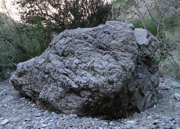
Below, Man resting on a most interesting mass, lots of smaller rocks embedded in what looked almost like concrete.  Somehow none of us could figure that there was a concrete truck out this far dumping his sludge, soooo, must have been the work of Mother Nature and a bit of molten rock.  This was deemed a very cool new thing for us.


Here is another shot that is a bit hard to see/describe, you are looking for the long whitish streak, running from top to bottom.  Believe this is some kind of molten lava fun, it is not caulk!  Well, not as far as we know it is not caulk!  LOL


Here is friend J standing at the top of this particular portion, he is shooting the same white streak from the top down.  The streak ran up, all the way up - - -   You can actually see it, barely, just to the left of where he is standing, beside that little boulder/rock. Yes, I know, difficult to spot.


Here is our first view of the "pouroff" area.  Here is the description of this walk, taken from the National Park Service web site:

"This trail leads through a gravel drainage, and ends in a narrow box canyon where water has carved a deep channel into Burro Mesa. The end of the trail is the base of a 100-foot pour-off. Usually dry, the smooth, polished pour-off attests to the power of water that floods this canyon during summer rains."


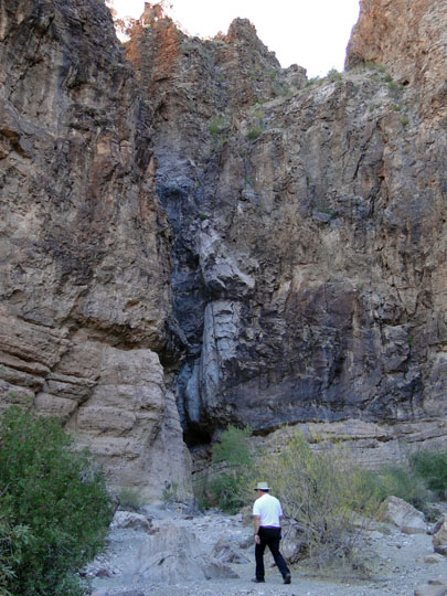
Another view, friend D looking UP UP UP, and polished it is, although it does not show particularly well in this photo.  The black section is where the water will rush down during summer storms.


This rock found nearby was criss-crossed, looked like elephant skin to me.  Another geological wonder to us.


Man and J each studying the geology and the wonder, further proof that no matter which way you look, up, down, and all around, there is something to investigate.  Much awe factor here.


We reluctantly left the "pouroff" and headed back out into the heat of the day.  We also headed over to Chisos Mountain Lodge for lunch, enjoying our last minutes in Big Bend National Park, trying to remember all we had seen and experienced.  Four great walks/hikes in four days, each different, one rather challenging (that U turn one) and all that great exercise, and tons and tons of photos.

Later this evening we will return to Terlingua, the cemetery was fascinating to a northern gal.  Yes, sometime some will show up here on Reflections.

We now turn north and west towards Arizona, but, we are NOT finished in Texas just yet!


* If you are interested in the geology there is a lengthy detailed discussion on this National Parks page.

** AccuWeather.com said it was 75 in the park on December 2nd.  I have no idea where they measure their temps.  I know, it is that dry heat thingy, it felt more like 80.  LOL


.

Monday, December 31, 2012

THE Trip, THE Encore' :: Shapes, Marvelous Shapes, Big Bend National Park.

Copyright 2012, CABS for Reflections From the Fence

December 1, 2012

After our hike at Santa Elena Canyon we continued our drive, first easterly, then, northerly along Ross Maxwell  Scenic Drive.  Best description, besides the ongoing huge and vast:

Shapes, its all about the shapes.

Below is one I can identify, Cerro Castellan, that fabulous structure to the left of the photo:

Ya, I had to try a panoramic of this one too, more vastness.


Almost like waves on the ocean, waves of sand and stone, pushed there by forces of nature and geology.  Look close you can see the waves cresting.


OK, this one is for my RVing friends, this is a campground.  Yep, flooding thanks to irrigation.  I have no idea why the are irrigating a campground, but there ya go.  This is the Cottonwood campground.  Nice if you have a very small camping unit and do not require power.  Plenty of water around tho - - 


In one area there was a lot of white, pure white, stone, almost looking like snow:


Lots of white stuff:


No idea what this is called, or if it even had a name.  Framed by brown ocotillo.


The two peaks on the far right are called Mule Ears Peaks, they top off at 3881 feet!


It is all about the shapes - - oh, and the textures - -


We all agreed this looked like a circus tent, real name, sorry, have no idea.


It was a long and wonderful day.  The next day will be our last in Big Bend, and unbeknownst to us, we saved the hike we all enjoyed the most till last.  Who knew??


.

THE Trip, THE Encore' :: Hike at Santa Elena Canyon, Big Bend National Park

Copyright 2012, CABS for Reflections From the Fence

December 1, 2012

On the day that Jolly took us down the unpaved Old Maverick Road, we had planned to stop at the Santa Elena Canyon, which came highly recommended.  We had our lunch at the picnic area at the beginning of the trail, and then, we were off, with hiking sticks, bottled water and of course, cameras ready to snap!

Maybe the best is first this time, the view of the canyon as you approach.  That is the Rio Grande River, Mexico to the left, US to the right. There are of course, signs that you should not cross the river.  We did not, but, I'll bet there are some that cannot resist the temptation, eh??


Turn just a little and you see the "hiking trail", yep, up there!


Yellow, again, smiling at us I believe.  (Thanks to friend Linda, the ID:  Wild Tobacco.  Draws hummingbirds, oh,yes, I am sure it does draw hummers!)


Starting up the trail:


Flora grows anywhere it can get a foot, err, root hold.  Prickly pear and cacti, not sure, maybe those hedge hog cacti.


Those walls are stunning, overwhelming, and, mmm, TALL!


Yes, I will share growing room with you:


Turn and look out of the canyon, back towards Big Bend and Texas and the US:


Can you guess what kind of plant this might be??


It is kin to the pineapple.  It is called Hechtia, and it only grows in the Big Bend country.  How cool is that??

Man and the trail where it got a bit more "natural".  The first part of the trail was full of switchbacks and stairs.


A little panoramic, looking out of the canyon, big country, big photo!


Upon leaving the canyon friend D spotted butterflies, lots of them.  The photo is over exposed shooting into the sun, but, you can see the butterflies!  LOL


Our day had more stops and more to do, next time - -


Sunday, December 30, 2012

THE Trip, THE Encore' :: BIg Bend National Park, Jolly Goes 4-Wheeling, We Go Along For The Ride

Copyright 2012, CABS for Reflections From the Fence

December 1, 2012

Friends that had visited Big Bend National Park before us gave us advice on what to see, the "really gotta see this stuff" list.  One stop we were informed was a MUST was to visit and preferably hike Santa Elena Canyon.    J, D, Man and I looked over the maps and decided that since the roads were dry we would tackle a unpaved road called the Old Maverick Road and drive it from the west Entrance at Maverick Junction, south to the canyon, about 13 miles of gravel roads.  The tour would continue in a counter-clock wise fashion through Castolon, and north along the Ross Maxell Scenic Drive to the Castolon/Santa Elena Junction and then west once more back to Study Butte.  (You  can find the map at the National Park Service web site, down the left side, look for View Park Map.)  This was going to be a long day, so we packed our lunches, bottled water, hats, cameras, extra batteries for the cameras, hiking shoes/boots, hiking sticks, maps, and we were off:

I did mention, didn't I, how vast and barren and harsh this park is, right??


And, I did mention, didn't I, that there has been four years of drought?  The ocotillo in much of the park were leafless, just dull brown sticks reaching to the sky.  Interestingly, along the Old Maverick Road the ocotillo were green and even blooming!  We were delighted and jumped out of Jolly to take many photos, 3 cameras going full tilt!


Lucky enough to find one plant that was rather short, I was able to get some really great close up shots of those beautiful RED RED RED flowers:


The road was graded, dug out in fact, you can see it is fairly large loose gravel.  Jolly got rather dusty!


Another vista view and the geology, ravines, hills, different sizes and colors of stones/gravel/sand, or what looks like sand.  Not a lot of fauna here though.


A bit more fauna here, ever changing desert life.


Our first goal for the day, Santa Elena Canyon, yes, we will hike it, yes, you know who took a bunch of photos, coming soon to Reflections.


.

THE Trip, THE Encore' :: Big Bend National Park, Moving Day

Copyright 2012, CABS for Reflections From the Fence

November 30, 2012

We had determined that a move from Stillwell to Study Butte would be advantageous and helpful for seeing the west side of Big Bend National Park, today was moving day.

We started out trying to find a geo-cache, sighhhh, 'twas a fail.  Our GPS units kept telling us the cache was on the other side of that gate and cattle grate.  The Geocaching web site told us it was not necessary to go onto the private property on the other side of that gate.  We even looked in the palm trees.  Sigh, for the fail.


So, after the fail, we left the interesting Stillwell Store and RV Ranch and headed south into the park and then west to Study Butte.  The haze and distances at times create eerie scenes, reminding me many times of old western movies I have seen,  mountain ranges, almost in silhouette, outlined by light, or lack of light.


Add a few unusual shapes, mysterious, loving the layers:


I am not even sure what to say about this structure, other than it sure is unusual.


An interesting view as we come down in elevation, looking out over the tops, sandy looking, smooth boulders, variance in colors and shades.  Barren, lonely, vast, huge, would not want to be out there wandering around, dangerous, did I say, huge?


Almost looks like a chimney, almost:


We arrived in Study Butte to find a rather vacant but modern campground, very clean.  Study Butte and Terlingua are physically close to each other, but, about as different as can be.  Study Butte is well, alive.  Terlingua is known as a ghost town.  Terlingua is not exactly a ghost town as there has been some rebirth, they are drawing in visitors with the story and mystique of the ghost town.  Terlingua has a great cemetery!  I'll show you soon.

We drove over to Terlingua later in the day as the sun was setting.  Just one of many abandoned homes in Terlingua.


I have no idea.  Looks to be a dragon fly or bee.  Why??  Who knows, but, I do love folk artsy type stuff.


Terlingua in the dusk of the day:


The next day will be back into the park, oh, my, it was quite the day, hiking, flora, space, huge, more, more more.


.