Wednesday, May 27, 2015

A Brief Respite on the Columbia River, near Portland Oregon :: THE Trip, THE Encore'

Copyright 2015, CABS for Reflections From the Fence

June 27, 2013, in Oregon, two years ago (well almost two years ago).

After driving the Historic Columbia River Highway easterly and seeing some (not all) of the beautiful waterfalls, we jumped on I-84 and headed west back towards, Portland and Troutdale.  We made one more stop, at a small turnout along I-84, which tells the story of Broughton's Expedition.

We stopped to take in the view of the Columbia River:


Sometime during our travels the last few years, I have taken to noticing and photographing surveyors marks, no I have no idea why, but, I seem to be rather taken by them.  I found at least 3 along this small pull off.  Here are two of the three:


This one seems to have been beaten on a time or two:


While I was hunting down surveyor marks and taking photos, Man was just gazing:


We sat and watched this barge moving down the river, just what is that yellow orb??


Well, sure, why not?  Be Happy.


It has been a long and wonderful day.  Several of our RVing friends had suggested we visit the Bonneville Lock and Dam and fishery.  I'll admit, I was hesitant.  I'll admit, I was nicely surprised.  Stay tuned.


.

Tuesday, May 26, 2015

Columbia River Gorge, Oregon, The Waterfalls :: THE Trip, THE Encore'

Copyright 2015, CABS for Reflections From the Fence

June 27, 2013, we were in Oregon, almost two years later, we are not in Oregon.

This first photo was actually the last waterfall photo of the day.  I want to present it first, because frankly, I don't care for it much, except that it shows a waterfall from I-84 as you head west.  I am not sure which falls these are, but, I love how you can see them from the expressway.  Taken from Jolly at 65 MPH, through a dirty buggy windshield with just a wee bit (sarcasm intended) of glare off the dash.


Now, where were we?  Oh, yes, after leaving Vista House, we continued driving easterly (on 30, the Historic Columbia River Highway, not the expressway, I-84)  and did water fall after water fall after - - 

I love water falls, don't you?  Now, some are harder to get to than others.  Sometimes you have to "hike" in. Sometimes finding a nice view to photograph is a bit of a challenge.  One needs to remind ourselves to be careful first, waterfalls can mean slippery surfaces.  There is the disclaimer, knowing full well that I would have loved to have more time and younger legs and body to scramble into more favorable positions.  Just sayin - - 

First stop, Latourell Falls, about 250 feet. You can hike the 2.1-mile loop trail to see the upper falls, we did not.


Next stop, Shepperd's Dell, the Wikipedia page states it is a bit difficult to get a photo of the falls, I do not disagree.


We had to walk down this rather steep walkway to see the falls here.  Thankfully, it was not too far.  Walkway was rather scenic.  Looked to be old WPA project, and covered with moss.  What's not to like?


And, there is a bridge involved:


The falls:


The falls AND the bridge:


Bridal Veil Falls, at Bridal Veil Creek, water runs from Larch Mountain, the falls are 120 foot tall.


A different kind of view, from the side as I approached. It is about 1 mile to the falls.  I believe this is one that Man sat out and I hiked it by myself.  It was not like I was by myself as there were many other hikers visiting the falls that day.


And, more or less, from the front.


Wahkeena Falls, the falls have 6 drops and totals about 242 feet.  It can be viewed from the roadway, which after my little hike to Bridal Falls is exactly what I did.


The falls are in there somewhere:


The famous Multnomah Falls.  There are 2 drops, total height of about 620 feet.  This area is more developed and is visited by many tourists.  There is a lodge, a large parking area and visitor services.  Multnomah Falls is the tallest waterfall in the state of Oregon.  A foot trail leads to Benson Footbridge, the 45-foot footbridge that allows visitors to cross 105 feet above the lower cascade.  Man and I did not go up to the footbridge.


Sony Too and panoramic, shooting from the bottom of the falls, upward.  Photos don't do the falls justice.


We did not stop at the Oneonta Falls,  going on instead to the Horsetail Falls, 192 feet tall.


There are many opportunities for hiking in this area, the rewards of course, being waterfalls.  This is one of those areas that certainly warrants a "do-over".  Tree dappled light, bright sun, wonderful blue skies, deep green flora, waterfalls of various shapes and sizes, the photographic challengers, definitely "do-over" fodder.


.

Columbia River Gorge, Oregon :: THE Trip, THE Encore'

Copyright 2015, CABS for Reflections From the Fence

June 27, 2013, yes, almost TWO full years ago.  Man and I are NOT in Oregon today.

After getting Tana all fixed up we moved Tana over to Troutdale Oregon. Our long term plan of driving the Olympic Peninsula was changed to, let's see the Columbia River.   In order to find a place to stay for the upcoming 4th of July holiday we would see Mount Rainier and more, places that had not been on our radar or bucket lists.  We were not disappointed, well, we were that we did not get to see the Olympic Peninsula, but, the substitute of Columbia River and Mount Rainier did not disappoint one bit.  In the long run, or as they say, in hind sight, we could not have been happier with this detour/change of plans.

We decided this day we would spend along the Columbia River Gorge, oooo, look, it is a National Scenic Area. You know that's gonna be good. This portion of our drive takes us along the southern side of the Columbia River, and we are driving east.


You know there will be bridges, of course.  This is the Stark Street Bridge, a 277-ft steel truss bridge spanning the Sandy River (two miles east of Troutdale, Oregon).  


And, rivers and water (yes, taken from the bridge).  The Sandy River.


And, there was the Chanticleer Point, with views to die for, the Columbia River, looking east.  The point is the first overlook encountered while driving east on the Historic Columbia River Highway, it is actually part of the Oregon state park system, called the Portland Women's Forum State Scenic Viewpoint. So worth the stop.


A little zoom and what do we have here??  Vista House, and yes, we will drive over and have a closer look.


The drive is pretty all along here, green, hills, curves - - 


Vista House, is an observatory and a memorial to Oregon pioneers.  It also served a comfort station for travelers on the Historic Columbia River Highway. The site is 733 feet above the Columbia River. The building is listed on the National Register of Historic Places.


Isn't it just exquisite?


The green used in the windows and roof are so different, and seem just so right for the setting and building.


Looking east up the Columbia River:


As we continue the drive we will visit a few waterfalls.  Coming soon!


.

Monday, May 25, 2015

Memorial Day, 2015 :: In Memory of Those That Gave the Most

Copyright 2015, CABS for Reflections From the Fence

The ultimate sacrifice.  Given by many.  We will not forget.


* Photo from a local cemetery.

.

Tuesday, May 19, 2015

THE Spruce Goose :: THE Trip, THE Encore'

Copyright 2015, CABS for Reflections From the Fence

June 24, 2013, two years ago, give or take a day or two, well, maybe a month.  We are NOT in Oregon today.

The Spruce Goose now resides at the Evergreen Aviation Museum, McMinnville Oregon. Their web site has a brief history of the Spruce Goose.   There is, of course, a Wikipedia page.  That page tells us:   "On November 2, 1947, the taxi tests began with Hughes at the controls. His crew included Dave Grant as copilot, two flight engineers, Don Smith and Joe Petrali, 16 mechanics, and two other flight crew. In addition, the H-4 carried seven invited guests from the press corps and an additional seven industry representatives. Thirty-six were on board."

The common story on how long the flight was, is: Hercules remained airborne at 70 ft off the water at a speed of 135 miles per hour for around a mile.  I found this at the museum, inside the plane, on display:


Date:  November 2, 1947
Nature of Flight:  First Tax Runs
Time in Air: Approx. 30 sec.
Repairs-Adjustments-Remarks:  After several taxi runs ship lifted about 25 ft in the air.
Signature D. Smith
License Number 6803641  (or 6803684 - - hard to read)

How interesting that Don Smith recorded the flight log data and recorded the length of the flight (time) to be about half of what all other sources state.

Now, let's have a look at this baby:


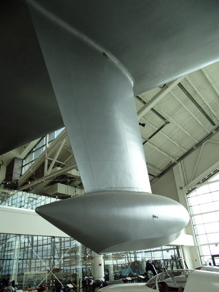
Seemed that no matter how far away I stood, I could not get the entire plane in one shot.  No zooming today.


Other guest waiting to tour the inside.


A helicopter suspended from the ceiling and other planes parked all around, the Spruce Goose makes them all look small, doesn't it?


Not all of the wing - - 


A docent giving a lesson on the Spruce Goose, what it was built of, birch, how it was moved to McMinnville, you know facts.


Inside, I thought this was interesting, seems Howard Hughes was fearful that the Spruce Goose would sink, so, one of the "improvements" he had made was to fill the lower hull and wing areas with inflated rubber bladders and beach balls.  They actually recovered one of the original beach balls in 2001 when the Spruce Goose was reassembled after the move to McMinnville.


Really is hard to believe just how large this plane is, ohhh, I already said that, didn't I?


One last attempt at capturing the entire plane in one photo, courtesy of the panoramic on Sony Too. Another fail. It is just too large and I could not move back any more. 


Just amazing, oh, and HUGE!

Yes, I enjoyed this museum very much.  The complex also includes a space museum.


.